loading ...
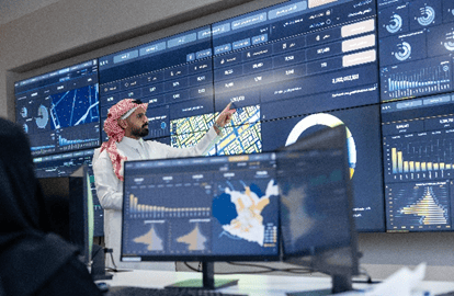 |  |
Urban Data Center is one of the strategic initiatives launched by the Riyadh Municipality, aimed at providing a unified and comprehensive platform for urban and spatial data of Riyadh City. It focuses on collecting, analyzing, and updating data to support sustainable urban planning in the capital. The center contributes to supporting digital transformation programs, achieving a cognitive city, and improving the quality of life in Riyadh by adopting global best practices in the field. It also serves as a key element in implementing Riyadh’s urban vision and aligning performance indicators with Saudi Vision 2030 and the Sustainable Development Goals (SDGs).
• Develop an integrated and flexible urban database that contains urban data at various levels.
• Conduct urban development studies for the city of Riyadh.
• Develop specialized urban applications and performance indicator dashboards for urban data.
• Build technical capacities in the fields of urban and spatial information systems.
• Leverage best practices and successful experiences in the fields of urban and spatial information systems.
Urban Data Center for the City of Riyadh focuses on achieving several key targets, most notably:
• Establishing a comprehensive and organized database that includes all data available to the municipality, linked with other governmental entities within Riyadh.
• Conducting urban analyses on the collected data to better understand the city and facilitate decision-making, thereby contributing to improving the quality of life for residents.
• Creating geospatial platforms, tools, and applications that enable the scientific and accurate presentation of all data and analyses conducted.
The center has contributed to the creation of several geospatial applications and tools, most notably:
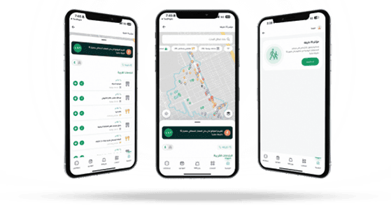
15-Minute Index: A tool within the "My City" platform that measures accessibility to essential daily services and activities within 15 minutes by walking or cycling. The services include healthcare, education, recreation, as well as transportation and others.
Riyadh Services Platform: An advanced platform that displays data on public services in the city of Riyadh, including educational services, healthcare, mosques, parks, and other services. It provides spatial tools that help analyze service levels and identify needs across the city.
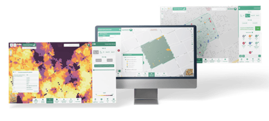
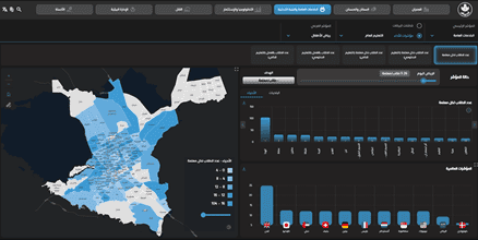
Neighborhood Evaluation: A detailed methodology, study, and specialized spatial tools designed to measure the quality of urban development in the city. It provides a clear assessment of the current status and trends of residential neighborhoods, identifies challenges they face, and offers recommendations accordingly.
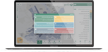
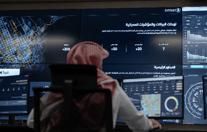
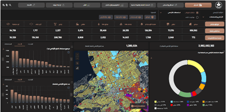
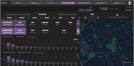
Urban Data Dashboards and Indicators: These are technical tools that provide interactive and visual display and analysis of urban data with the aims to:
Understand, analyze, and review urban data
Support decision-making
Monitor urban performance
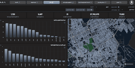
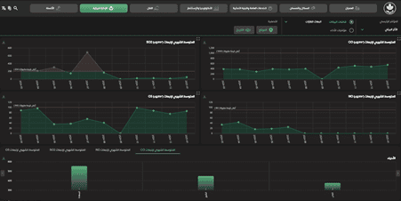
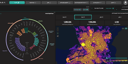
The work of the urban data dashboards and indicators is based on a unified geographic database covering seven main axes:
1- Urban Development: This axis focuses on a comprehensive study of aspects related to building systems, urban codes, land uses, and other elements within urban lands and plans. It also highlights Riyadh’s major and distinctive projects and landmarks.
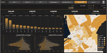
2-Population and Housing: This axis focuses on population studies and includes various statistics such as population distribution, population pyramid, population density, and more. It also covers the study of housing ownership diversity, types of housing, and real estate indicators.
3-Public Services and Infrastructure: This axis focuses on the various public services and their distribution across Riyadh’s neighborhoods, as well as the extent of the city’s coverage by basic infrastructure.
4-Technology and Investment: This axis focuses on studying the rate of expenditure and annual GDP, various investment opportunities, different economic activities, and all aspects related to the technological and digital landscape of Riyadh.
5-Transportation: This axis covers the study of public and private transportation, the road network, sidewalks, and bridges. It also presents traffic flow and congestion through various statistics and visual charts.
6-Environmental Management: This axis focuses on studying the environmental impact and key environmental issues affecting the city of Riyadh, using a set of statistics and performance indicators.
7-Humanization: This axis focuses on aspects related to urban development and improving the quality of life in the city. It includes evaluating public services across Riyadh’s neighborhoods and gathering residents’ and users’ feedback on public facilities and services, presented through various statistics and visual charts.
Amid the rapid transformations taking place in Riyadh as a vibrant urban hub, the Urban Data Center plays a vital role as a key enabler of sustainable development and enhanced efficiency in planning and governance. The center works to build an integrated system based on advanced data technologies, offering strategic contributions that help shape a smarter and more sustainable future for the capital. Among its most notable contributions:
• Enhancing data integration by providing a centralized platform for unified urban data in Riyadh.
• Improving the reliability and accuracy of data to support strategic decision-making for relevant authorities.
• Producing advanced indicators and dashboards to monitor urban trends and patterns.
• Improving the efficiency of data-driven urban planning.
• Promoting coordination and integration between public and private sector entities.
• Enabling urban investments based on accurate data.
• Supporting the achievement of Sustainable Development Goals and Saudi Vision 2030.
In addition to the tangible achievements made by the Urban Data Center, it is expected to become a key enabler of innovation and the development of smart services. This will be achieved by expanding the use of artificial intelligence and predictive analytics to enhance strategic urban planning capabilities. The center aims to provide an integrated data environment that supports the development of innovative urban solutions, contributing to improved infrastructure efficiency, better service quality, and more accurate and rapid response to residents’ needs. Ultimately, it seeks to lead the transformation toward cognitive cities that can adapt to future changes while achieving a balance between sustainable development and community well-being.
Urban Data Center of Riyadh City received the Excellence Award in Smart Cities and Urban Planning during the Geospatial World Forum 2025, in recognition of the Center’s pioneering efforts in developing a unified digital platform that supports decision-making and leverages geospatial data to enhance the efficiency of urban planning and the quality of life in the capital.
No comments have been added yet
Last Update:
09/09/2025
5 visitors liked the page content out of 5 shares